ST. GEORGE – The Bureau of Land Management St. George Field Office is accepting public comments on an environmental assessment analyzing a proposed land exchange between BLM and Brennan Holdings, LLC. The comment period opened April 5 and ends May 5.

If the exchange is approved, BLM would acquire private land in the Red Cliffs Desert Reserve north of St. George near the Green Springs development and golf course. In exchange, developer Bob Brennan’s company, Brennan Holdings, would acquire approximately 605 acres of public land in Long Valley, just east of Washington City.
The proposed exchange is part of an ongoing effort by BLM, Washington County and the Habitat Conservation Plan Advisory Committee to acquire 1,288 remaining acres of privately-owned land within the reserve.
The Red Cliffs Desert Reserve was created 20 years ago to protect the endangered Mojave desert tortoise while allowing development to continue in the rest of Washington County. The Habitat Conservation Plan expired in March; however, the existing permit remains in place, and the renewal application process is ongoing.
Read more: Habitat Conservation Plan expires after 20 years of protecting tortoises; renewal efforts continue
Under the terms of the Habitat Conservation Plan, the remaining private property within the reserve must either be purchased outright or traded for land of equal value. Developer Bob Brennan is the largest remaining landowner, with about 800 acres still in the reserve. The proposed trade would exchange 605 acres in Long Valley for between 80 and 180 acres of Brennan’s property, depending on the appraised value of the two properties.
Read more: Habitat conservation committee works on Long Valley exchange, trail monitoring
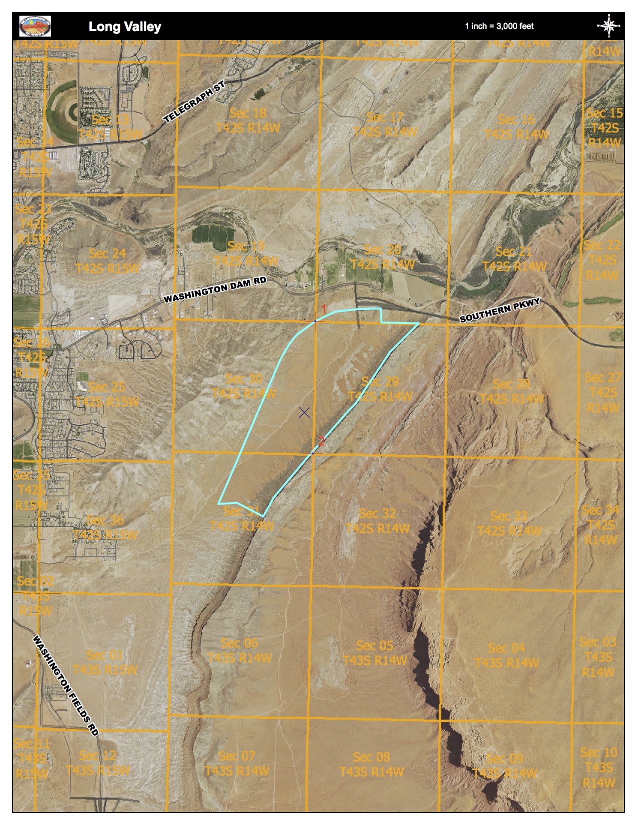
The Long Valley parcel is located in unincorporated Washington County land approximately 1.5 miles from the new St. George Airport, 6 miles east of St. George and just outside of the city limits of Washington City between Washington Dome and Warner Ridge.
The property is within the 40,000-acre Sand Mountain Special Recreation Management Area. However, it is not within the open travel area, and because of its location and physical features, it is not heavily used for motorized recreation, according to the environmental assessment.
The National Environmental Policy Act requires some level of environmental assessment when a public land transfer is made, Red Cliffs National Conservation Area manager Dawna Ferris-Rowley said.
Archaeological surveys have been ongoing on the Long Valley property, and Ferris-Rowley said some historic and prehistoric sites have been found, including structures built by the Leeds Camp of the Civilian Conservation Corps.
“These are CCC, 1930s-era soil erosion control features,” Ferris-Rowley said. “Stacks of rock in some cases or mounds of dirt used to kind of slow the water down as it was coming off the sides of the Hurricane Cliffs, the Warner Valley Ridge out and to prevent it from creating erosion on those parcels as it heads towards the Virgin River and the Washington Canal.”
Preserving these structures will be done digitally through a Historic American Landscape Survey using historical research, photographs and measured sketch drawings. The information will be sent to the Library of Congress.
“We’re losing people that have any recollection of that 1930s period and all the interesting things that the (Civilian Conservation Corps) were involved in, in saving the West, if you will, from erosion and deforestation.”
Prehistoric sites will require processing by archaeologists using traditional methods to preserve information and artifacts.
How to comment:
A copy of the environmental assessment is available for review on the BLM’s ePlanning website. Comments can be submitted electronically through this site.
Comments can also be mailed or hand-delivered to:
BLM-Utah St. George Field Office
Attn: John Kellam
345 East Riverside Drive
St. George, Utah 84790
Please reference “Red Cliffs/Long Valley Exchange EA” when submitting comments.
According to BLM, the most useful comments contain new technical or scientific information relevant to the proposed action. Comments should be as specific as possible. Comments which contain only opinions or preferences will not receive a formal response but may be considered in the BLM decision-making process.
Before including an address, phone number, email address or other personally identifiable information in any comments, commenters should be aware that the entire comment – including personal identifying information – may be made publicly available at any time. Requests to withhold personal identifying information from public review can be submitted, but the BLM cannot guarantee that it will be able to do so.
For additional information regarding the proposed exchange, contact John Kellam at 435-688-3333. Persons who use a telecommunications device for the deaf, or TDD, may call the Federal Information Relay Service at 1-800-877-8339 to leave a message or question for the above individual. The FIRS is available 24 hours a day, seven days a week. Replies are provided during normal business hours.
Email: [email protected]
Twitter: @STGnews
Copyright St. George News, SaintGeorgeUtah.com LLC, 2016, all rights reserved.
Wait, he has 800 acres you want. But you’re going to give him 605 acres of land on a major future road, just north of the airport, that will soon be worth ridiculous amounts of money, and you’re only going to get 80 – 180 in return? Look at that area in Google Earth and note the direct access to the airport and the corridor to Hurricane and Sand Hollow. I’m sure they can find an appraiser that will overlook that while doing the valuation.
Who does this guy have compromising pictures of?
I swear, every single aspect of the current BLM and Red Cliffs Desert Reserve makes me regret every penny of taxes I’ve ever paid. It seems like none of it is about protecting tortoises, owls, spotted / striped fish, or some little mythical snail near Kanab. It’s all about power, control, and lining the right pockets.
Every time I think about the corruption in Washington County, it causes me to lose hope that we’ll ever get it right in Washington DC…
Let the Red Cliffs Desert Reserve expire (or stay expired).
You are absolutely correct Brian!
It’s about conserving and preserving…more preserving till a later date…and conserving time when to do so. The owner will be forced into the trade. The BLM knows exactly whats under this specific area to do a trade like this. But of course the BLM already ransacked and defaced this other area so they put up an offer that seems to good to be true. Since my last post about “seen from above”…they have, since then removed, blurred and overlay’d a haze to make those particular spots unnoticeable. What they are doing is making a certain area off limits to motorized vehicles because it limits people from further seeing and noticing what’s actually back there. Hidden behind endangered species which they planted…only to buy them time to “do what they do”, which is “salvaging” for their own greed! Defacing and removal of Meso-American artifacts…and anything to relate, correlate…and or evidence that this area was once inhabited by a Southern Culture most notorious for having huge amounts of GOLD! Today…I took a drive up the turkey farm road looking to go hiking but ended up watching dark colored military helicopter sneaking its way up the canyon real low and disappearing into Washington Hollow. Its not about endangered species…or rare plants…it’s exactly what you said…lining of ones pockets! Its what the standoff in Oregon was about…at least on part of the BLM. It’s what recapture canyon was about…even this here…in our county. It goes on and on and on…but I see why. Its to save face and a lie…because someone made a group based on plates of gold that were deciphered wrong and what was originally thought to be holy…turned out to be scripts from civilization who’s GOD, was a horned serpent from below. You can’t buy the truth…but you can try to hide it…and that’s whats going on!