UPDATED 2:15 p.m. with current information on the Saddle Fire.
ST. GEORGE — A drone flying near the Aspen and Pine Canyon fires in Southern Utah has grounded all aerial firefighting efforts, dealing a setback to efforts to contain the blazes.
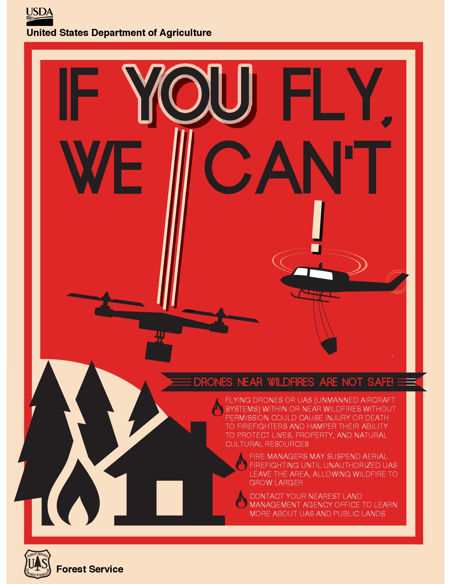
“At about 10:30 this morning we had a report of a drone,” Nick Howell, incident commander for the Aspen fire, said. “Multiple crews were impacted by this action. We were forced to shut down aircraft and ground everything we were using to support the crews on the line.”
Multiple law enforcement units are currently seeking out the drone operator, he said.
Because a flight restriction is in place – within a 7-mile radius of the fires – any unauthorized aircraft not on the official flight schedule that are seen in the area cause an immediate and total suspension of all flights for safety concerns, Howell said.
Until the drone pilot is found, and the unauthorized aircraft removed from the area, no aerial firefighting crews can return to fighting the fires.
“I don’t think a lot of people know, but drones are restricted by the FAA,” he said, “and when there’s a flight restriction over wildfires it is pretty serious business. There are fines and you can and will get cited.”
According to a press release from the Federal Aviation Administration, any drone pilot who endangers manned aircraft or people on the ground is liable for fines ranging from $1,000 to a maximum of $25,000.
Three active fires
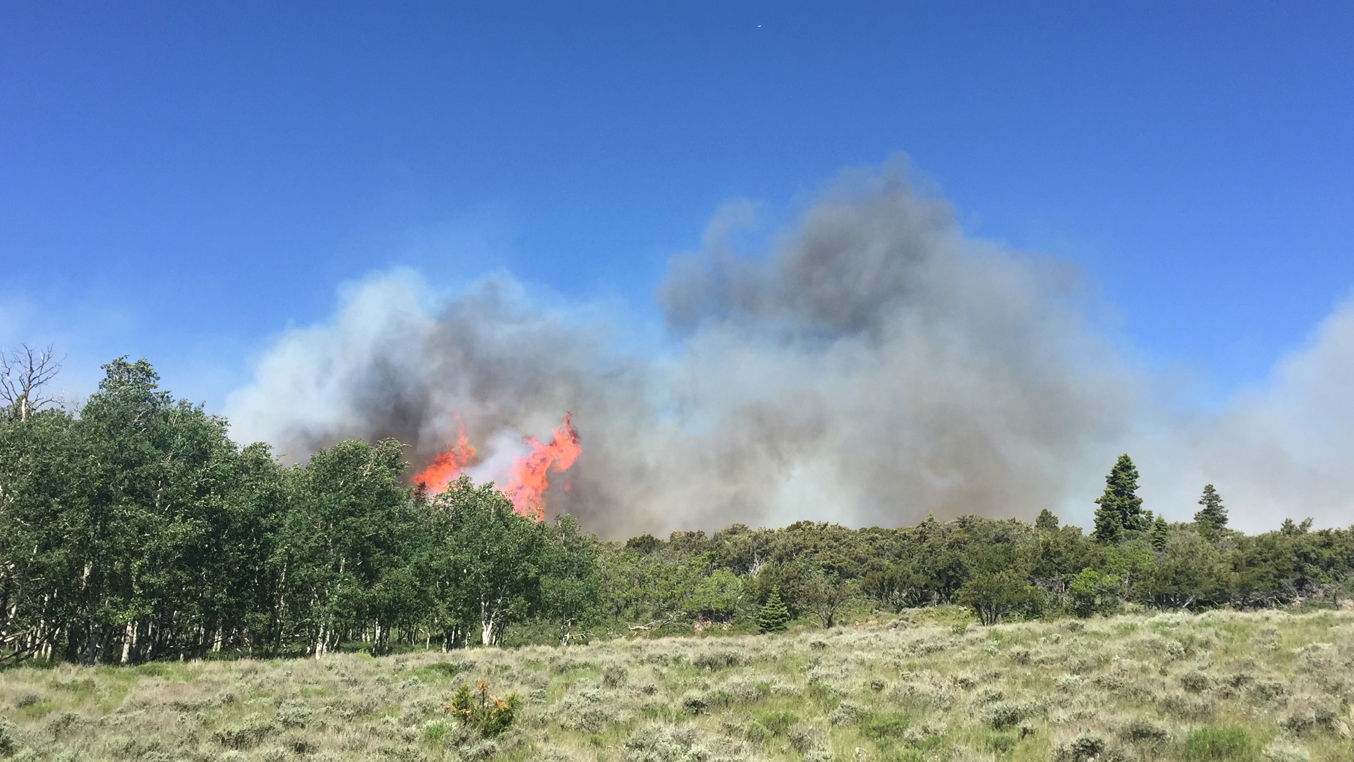
There are three lightning-caused fires currently being addressed in the Pine Valley Ranger District of Dixie National Forest: The Saddle Fire in the Pine Valley Wilderness Area, the Pine Canyon Fire and the Aspen Fire.
The Pine Canyon Fire is a lightning-caused fire that was reported Wednesday. It is currently being held at 105 acres, according to a Sunday morning news release from te Pine Valley Ranger District of Dixie National Forest where it is located.

The Pine Canyon fire is currently 76 percent contained. Crews continue to make good progress securing the fire edge and mopping up hot spots with helicopter support.
The Aspen Fire, also a lightning-caused fire, is located 2 miles north of the Pine Canyon Fire and about 15 miles southwest of Cedar City on Bumblebee Mountain off state Route 56. It was first reported around 3 a.m. Wednesday and is being held at 355 acres.
The Aspen Fire is 50 percent contained, according to the Sunday morning news release. High winds continue to persist over the fire. Existing control lines are holding and will be improved throughout the shift today, according to the release. Crews continue to secure fire edge and mop up hot spots with the aid of Helicopters. All roads leading to the Bumblebee repeater are closed.
No evacuations are in effect although 20 scattered structures, including homes and outbuildings are currently threatened.
Bumblebee Spring Road is closed.
The Saddle Fire was reported on Monday and has now burned approximately 318 acres, according to a Sunday afternoon news release. It started on Saddle Mountain and is located in the Pine Valley Wilderness approximately 2.5 miles southwest of the unincorporated town of Pine Valley.
The Saddle fire is not contained.
Fire crews are improving existing fire breaks and helping Pine Valley and Central residents and visitors prepare for the moment the fire moves off the steep, rocky ridges of Saddle Mountain and into an area firefighters can attack safely.
“We had a community meeting last night and were able to explain this from the start of the fire to our plan of attack,” Saddle Fire incident commander Chris Henrie said. “I feel like we are all on the same page and are ready for the next step.”
Firefighters have worked on clearing and expanding roads and trails that will double as fire breaks to help keep the community safe.
Additionally, firefighters are building structure assessment plans for Pine Valley and Central homes to help property owners make their homes more defensible against fire.
Currently the Goat Spring Trail is closed and no other recreational areas are affected. The objectives of the incident are to ensure firefighter and public safety through the use of sound risk management and hazard mitigation, and protect infrastructure in communities, campgrounds, private lands, water systems, and municipal watersheds.
Sunday firefighting missions canceled
Two missions for Sunday were canceled due to the drone, Howell said. One mission was to haul massive bags of water — or blivets — to strategic points on the fire line for use by ground forces. The other canceled mission involved repeated flights of helicopters making water bucket drops directly on the fire.
“It’s a huge deal and we take it really seriously,” he said. “Not only does it hamper our containment efforts, it puts a lot of people at risk.”
Drone interference is becoming a more common problem, Howell said. Last year there were multiple fires where drones appeared and aerial forces were shut down
“The result of that is the fire gets a lot bigger and puts firefighters at risk and that ultimately costs the taxpayers more money,” he said.
The message he would like to get out to the public is simple. He said:
If you fly your drones, we can’t fly our aircraft. The two are a really bad combination. We have these flight restrictions over emergency areas for a reason. It would be nice if the public would respect those flight restrictions.
The National Forest Service – Dixie National Forest Facebook page said “We would like to remind all Drone users that it is illegal to fly a drone near any wildfire and also there is a SEVEN MILE Temporary flight restriction over the fires we are currently managing.”
Firefighting resources
Interagency resources on scene for Aspen and Pine Canyon fires include seven engines, two dozers, three helicopters, five single engine air tankers – or S.E.A.T.’s, three heavy air tankers, nine Type 1 Hotshot handcrews, nine Type 2 handcrews with 475 total personnel currently assigned.
The Color Country Type 3 Incident Management Team continues to utilize ground and aerial resources (subject to today’s grounding due to the drone) while re-evaluating the fire to best plan the next actions and ensure success and safety throughout the incident. The number one priority will be for firefighter and public safety when making management decisions.
One firefighter was injured Thursday and was medically evacuated from the fire to Dixie Regional Medical Center in St. George. The firefighter sustained a head injury due to a fall. The firefighter has been released from the Hospital and is expected to make a full recovery. No other injuries are reported.
Interagency resources working the Saddle Fire include two Type 1 Interagency Hotshot crews, four Type 2 initial attack crews, one Type 3 incident management team, eight engines, two Type 3 helicopters (based in Pine Valley and carry up to 100 gallons), one Type 1 helicopter (based in Cedar City and carries up to 700 gallons), two Type 3 personnel – 175 firefighters assigned (includes all staff and crews).
Resources
To receive alerts for emergencies and other important community messages by signing up for the Citizen Alert System for Iron County and surrounding cities.
A fire information center has been established at the fire station in Central. For further information please follow the Dixie National Forest on Facbook, Twitter, and utahfireinfo.gov.
Email: [email protected]
Twitter: @STGnews
Copyright St. George News, SaintGeorgeUtah.com LLC, 2016, all rights reserved.
Drone pilots, also known as ignorant, interfering a**hats, should be held accountable for more than the measly fines mentioned above. People’s lives and property are at serious risk. The judicial system in our country, and in our area, needs to wake up and deal with these types more seriously.
They should be able to shoot these drones down and then when the drone owner starts whining, slap them with a few nights in jail and a huge fine.
I wish people would use common sense with their drones. I hope they find the pilot and press charges. Our son is working that fire along with many others. This is putting their lives in danger. For what? Some photos.
This is about as ridiculous as the forest ranger getting lost ON TOP of Pine Valley Mountain! It’ll be like an Easter egg hunt with BLM and others chasing to DEFACE/LOOT all the new ruins the fire exposes! A drone is about as big as a small hawk or crow and do fires get shut down when one of these types is seen in the area of one???? Just goes to show that there is more to this than ” if you fly, we cant fly” ridiculousness!
and this UNTIL WE FIND WHO THEY WERE! Illegal acts caught on drone footage maybe????
A bird is smart enough not to fly around a hovering helicopter. A selfish, grandiose drone pilot is not. These are human lives in those helicopters. Back off and let them do their already dangerous jobs. Selfishness, not responsibleness, is taking over.
Oops! Sorry…..carry on
Okey Dokey !
To many drone pilots do not understand the dangers of flying drones around manned aircraft and in restricted airspace. As a commercial helicopter pilot and commercially licensed drone operator through the FAA, our drone company AirVidTech is restricted when, where, and how we fly our drones so that we operate in a safe and professional manner. Anyone piloting a drone as a hobby or commercially needs to understand the laws associated with drone flight and safe practices. Check out FAA.gov for advice on safe flight.