ST. GEORGE – A storm moving from western Utah eastward across Utah has given rise to warnings and alerts Sunday from the National Weather Service and Utah Department of Transportation with heavy snow and strong winds included in the forecast for various regions. Heavy snow with strong and gusty winds will impact travel, in some cases reducing visibility to zero.

Take caution when traveling roads and highways in the forecast conditions and be prepared with winter survival items in your vehicles for emergency.
The forecast and alert periods range from 10 a.m. Sunday to Tuesday morning.
Utah Department of Transportation has issued an emergency road alert Sunday for state Route 143 in Iron County. The route is closed between mileposts 17-28, past Brian Head to Mammoth Creek due to weather.
With a cold front moving in Monday, UDOT foresees road snow and slush possible on all of Interstate 15 by Monday morning.
More road alerts below.
Areas affected
Cities in the southern mountain area warnings from the Weather Service include Loa, Panguitch, Bryce Canyon, among others.
To the north and southwest – southern Wasatch Front, Great Salk Desert and mountains, western Uinta Basin and southwest Utah – cities include Lehi, Provo, Nephi, Wendover, Snowville, Duchesne, Roosevelt, Beaver, Cedar City and Milford.

Snow accumulations and levels
In the southern mountain region, 1-2 feet or more of snow accumulations are expected.
In the north and southwest regions, 3-7 inches are expected generally with locally higher amounts above 5,500 feet. Snow levels for these areas, except for the Uinta Basin, may rise to near 5,000 feet overnight Sunday and into Monday before falling back to the valley floor.
Timing
Higher valley routes in Southern Utah, including higher portions of I-15 from Scipio southward, will see road snow and slush by late Sunday morning, according to UDOT.
Snow will develop in the southern mountain areas by Sunday afternoon, according to the Weather Service, and then continue heavy at times through Monday before decreasing Monday evening.
To the north and southwest, the service warning states, precipitation may mix with or turn to rain for a period Sunday night into Monday morning except in the Uinta Basin.
Winds
Southern mountain regions are expected to experience strong gusty southwest winds in excess of 70 mph on the ridgetops Sunday through Tuesday morning.
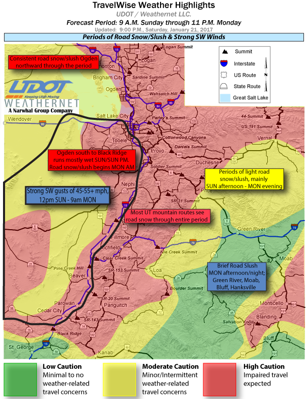
Southwest Utah, similarly, is expected to experience strong gusty southwest winds late Sunday into Monday morning with gusts up to 50-55 mph. These winds may cause blowing and drifting snow across the region.
Road and travel impacts
Significant travel impacts are anticipated. Winter driving conditions are expected. Blowing and drifting snow will cause areas of near zero visibility. These restrictions on visibility may come suddenly due to blowing snow.
Many valley routes and lower portions of I-15 south of Ogden will see a rain-snow mix through the day and night with wet roads expected. UDOT expects routes north of Ogden to see road snow and slush late Sunday morning and continuing through Monday night.
Most mountain routes across the state will see periods of road snow through Monday night as well. UDOT anticipates higher portions of Interstate 70 and summit routes in southeast Utah will see road snow and slush Sunday afternoon and throughout Monday.
Across the state, UDOT foresees travel concerns on I-15 from the Idaho border through Black Ridge at milepost 36; the entire routes covered by Interstates 15, 80, 70, 84 and 215; the entire routes covered by U.S. Highways 89, 189, 40, 191 and 6.
In Washington County, state Routes 18 and 9 across the Pine Valley Mountain and Zion National Park regions are expected to see road snow and slush by 9 a.m. and 10 a.m., respectively, continuing into Monday.
In addition to the closure of SR-143 between mileposts 17-28 in Iron County, state Routes 14 and 143, among others, are expected to see road snow by 10 a.m. Sunday, continuing into Monday.
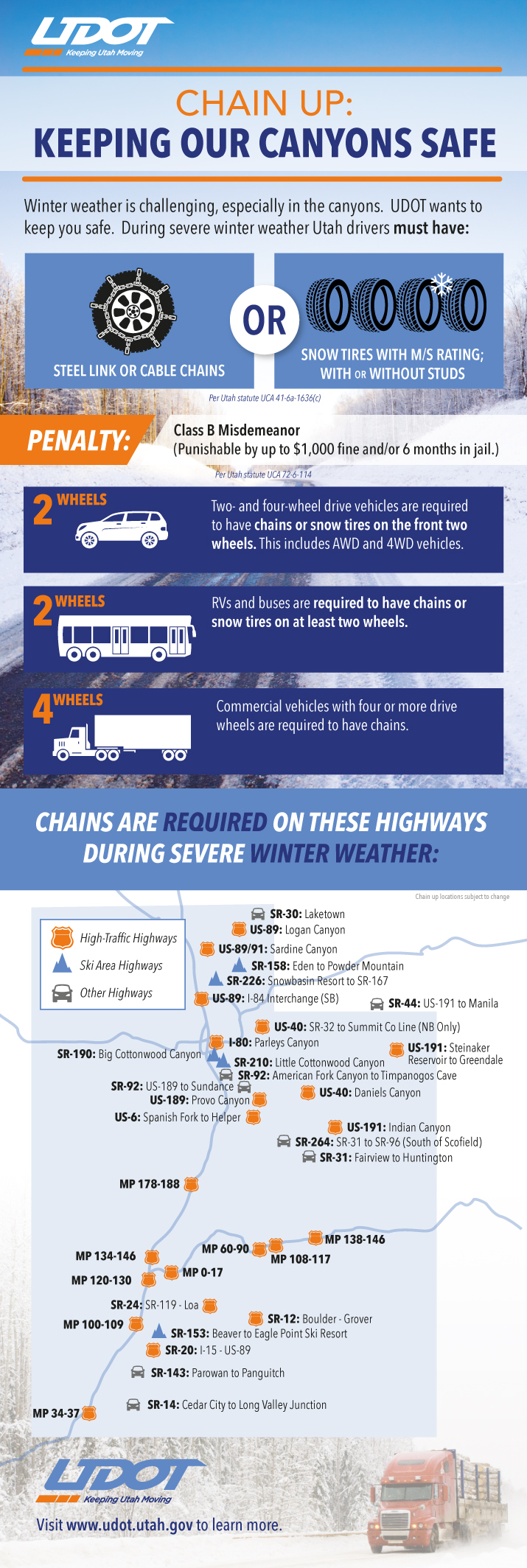
For more specific information on roads and highways across the state see UDOT’s road weather alert webpage.
Precautionary/preparedness actions
Those traveling are admonished to take a winter survival kit in their vehicles including warm clothes and blankets, extra food and water flashlight and batteries, among other things.
Vehicle preparation and safety precautions for winter weather
Stay in your vehicle
- Disorientation occurs quickly in wind-driven snow and cold.
- Run the motor about 10 minutes each hour for heat.
- Open the window a little for fresh air to avoid carbon monoxide poisoning.
- Make sure the exhaust pipe is not blocked.
- Make yourself visible to rescuers.
- Turn on the dome light at night when running engine.
- Tie a colored cloth (preferably red) to your antenna or door.
- Raise the hood indicating trouble after snow stops falling.
- Exercise from time to time, by vigorously moving arms, legs, fingers and toes to keep blood circulating and to keep warm.
- Wear a hat; half your body heat loss can be from the head.
- Cover your mouth to protect your lungs from extreme cold.
- Mittens, snug at the wrist, are better than gloves.
- Loose-fitting, lightweight, warm clothing in several layers is best. Trapped air insulates, and layers can be removed to avoid perspiration and subsequent chills.
- Outer garments should be tightly woven, water repellent and hooded.
- Safely removing tires and upholstery from your vehicle and lighting them on fire in a cleared area will create smoke to facilitate your being located.
Supplies recommended to keep in your vehicle in case of emergencies
- Cellphone, portable charger and extra batteries.
- Windshield scraper.
- Battery-powered radio, extra batteries.
- Flashlights, extra batteries.
- Snack food.
- Extra hats, coats, mittens, change of clothes.
- Blankets.
- Chains or rope.
- Tire chains.
- Spare gas.
- Canned compressed air with sealant (emergency tire repair).
- Road salt and sand.
- Booster / jumper cables.
- Emergency flares.
- Bright colored flag; help signs.
- Lighter / matches (waterproof matches and a can to melt snow for water).
- First aid kit – (Basic first aid courses are recommended).
- Spare water.
- Hi-lift jack.
- Spare tire with keys for locking lug nuts.
- Spare keys.
- Shovel.
- Tow strap.
- Tool kit.
- Duct tape.
- Trash bags.
- Road maps.
- Compass.
- Towels, paper towels.
The above recommendations were compiled in 2015 from the Washington County Sheriff’s Search and Rescue website, the Center for Disease Control’s emergency winter weather checklist, the U.S. Search and Rescue Task Force’s website on blizzard preparedness. This is a list of suggestions, in no particular order of priority, and should not be presumed exhaustive.
Printable / savable pdf: Vehicle Preparation and Safety Precautions for Winter Weather.
Email: [email protected]
Twitter: @STGnews
Copyright St. George News, SaintGeorgeUtah.com LLC, 2017, all rights reserved.